Episode 4
Episode 104 | 42m 49sVideo has Closed Captions
The final leg starts in the Isles of Scilly, strewn with shipwrecks and ancient ruins.
Known as ‘Britain’s subtropical secret’, the Isles of Scilly are filled with dazzling beaches and exotic wildlife. Voyage through England's South Coast diving with blue sharks, exploring battlements of Drake's Island, learning the origins of Scouts. Meet the royalty of the world’s smallest micro-nation, find naturalized scorpions and explore WW2 sea forts.
Episode 4
Episode 104 | 42m 49sVideo has Closed Captions
Known as ‘Britain’s subtropical secret’, the Isles of Scilly are filled with dazzling beaches and exotic wildlife. Voyage through England's South Coast diving with blue sharks, exploring battlements of Drake's Island, learning the origins of Scouts. Meet the royalty of the world’s smallest micro-nation, find naturalized scorpions and explore WW2 sea forts.
How to Watch Britain's Secret Islands
Britain's Secret Islands is available to stream on pbs.org and the free PBS App, available on iPhone, Apple TV, Android TV, Android smartphones, Amazon Fire TV, Amazon Fire Tablet, Roku, Samsung Smart TV, and Vizio.
Providing Support for PBS.org
Learn Moreabout PBS online sponsorship-We're sailing around the U.K. in a historic tall ship to explore its secret islands, to discover the untold stories of the history, cultures, and wildlife that they hold.
♪♪ From 5,000-year-old ruins, to fascinating living cultures with links to Viking heritage, these are found across the 6,000 islands that make up the United Kingdom.
♪♪ In our journey, we're hoping to unveil the mystery of the islands that form the British Isles.
♪♪ So join us in this voyage of discovery to "Britain's Secret Islands".
♪♪ We set sail on our journey from Greenwich aboard the tall ship the Pelican of London.
♪♪ We're sailing thousands of kilometers right around the edge of Britain on our voyage to discover its islands and waters.
♪♪ Now we're heading to the Isles of Scilly, an archipelago 45 kilometers off the Cornish coast.
The Isles of Scilly are made up of more than 140 islands and are notorious to mariners because of their dangerous waters.
There are almost 1,000 shipwrecks around the 160 kilometers of coastline, so we have to approach with extreme caution.
During the night, the fog has descended, and now you can only see a couple of hundred meters.
This really underscores why these waters are so dangerous and why there were so many shipwrecks here.
Even today, a bell is rung every 60 seconds as a warning to other ships that might be approaching so they can listen out and hear us in the fog.
[ Bell ringing ] [ Waves crashing ] The position of the islands at the junction of shipping routes to the English Channel have made them known as the "Ships' Graveyard".
To find out just why these waters are so treacherous, we're going beneath the waves.
♪♪ Immediately, you can see that the islands are surrounded by razor sharp skerries and rocky reefs, and the sea is often no deeper than ten meters.
♪♪ Over the centuries, this has led to hundreds of shipwrecks which have claimed thousands of lives.
♪♪ In one incident alone, in 1707, the islands became the scene of one of Britain's worst maritime disasters.
♪♪ A fleet of 21 Royal Navy ships led by the flagship HMS Association, headed from Gibraltar to Portsmouth.
[ Water gently lapping ] [ Waves crashing ] The ships were hopelessly lost in the bad weather, and six were driven onto the rocks.
[ Waves crashing ] Four of the ships sank or capsized, with nearly 1,500 dead, including those from the flagship.
♪♪ This is the wreck of the Italia, a near 3,000-ton steamship which was carrying coal from Cardiff to Toronto.
She came aground in May 1917, in dense fog and a westerly gale.
The bow of the Italia lies in a steep, sloping gully.
You can see that the iron propeller is still fixed to the shaft.
♪♪ And the wreck has become an artificial reef for marine life.
♪♪ Those ships which do make the safe passage usually dock in St. Mary's Harbour, which is the gateway to the Isles of Scilly.
There's a total population of about 2,200 people living here, mostly on the largest island, St. Mary's.
The islands have been inhabited since Neolithic times and have distinctive burial chambers known as entrance graves, made up of great stone and earth mounds.
When one of the chambers was excavated, it was found to contain cremated human bones and broken pottery, which may have been the remains of a funerary urn.
♪♪ By the 16th century, the Isles of Scilly were a weak spot in Britain's defenses, and the coastline was frequently attacked by Barbary pirates from North Africa.
♪♪ The pirates captured residents for the slave trade, and with concerns that the islands could be controlled by France or Spain, they were heavily fortified during the Middle Ages.
♪♪ Blockhouses and artillery forts were built to protect the harbor.
These are small defensive structures with a gun platform and four-pounder cannons that could fire a shot up to 1,200 meters.
♪♪ Standing proudly on a promontory is Cromwell's Castle.
This blockhouse was built when Parliamentarian forces captured the islands from the Royalists in 1651, at the end of the English Civil War.
The castle was named in honor of the Parliamentary leader Oliver Cromwell and is one of the few surviving Cromwellian fortifications in Britain.
♪♪ After centuries of turbulent history, peace has once again been restored to the islands, which today are known for their dazzling white beaches and azure waters warmed by the Gulf Stream.
♪♪ The Isles of Scilly completely challenge the old stereotype of Britain being cold, wet, rainy islands with muddy beaches.
This place is more like the Caribbean.
[ Birdsong ] Known as Britain's subtropical secret, these islands are the most southerly part of the British Isles.
Warmed by the waters of the Gulf Stream, they have a stable, mild climate perfect for exotic plants.
Tresco is the second largest island and is famous for the Tresco Abbey garden.
♪♪ It was founded as a private garden in the 19th century, in the ruins of a Benedictine abbey.
There are seven hectares of walkways and south-facing terraces, where you'll find plants from more than 80 countries.
♪♪ This king protea from South Africa would never grow outside on mainland Britain.
The winter conditions would just kill it.
But look here, it's thriving.
The vegetation here is just so lush and beautiful.
The warm climate here brings real benefits to the economy, and the island's flower industry is now second only to tourism.
Zoe Julian, who's been living on the islands for 20 years, explains how it all began.
-It all started here because the Dorrien-Smith family, who still run Tresco, realized that if their tenant farmers couldn't make any money, the estate didn't really work.
So they went away and found a bulb -- a bulb flower that could be grown on Scilly and would work well.
And that was basically a cash crop.
And that was in the 1800s.
The railway obviously came to Penzance at that time as well, which meant that the flowers could be exported effectively and quickly up to London.
And there was a burgeoning middle class at that time, and there was a fashion for cut flowers to go into people's drawing rooms to make them look beautiful.
And then the flower industry took off.
And Scilly -- the climate on Scilly means that it was really the only place in the country where you could grow cut flowers over the winter months.
-And it's all down to the weather here.
-The climate of Scilly means that we rarely, rarely get frosts, and so we can have a little bit of an advantage.
The water around us sort of acts like a bit of a giant blanket through the winter.
And so the climate means that we can start picking scented narcissi in October.
Whereas people sort of think of those flowers as a spring flower, we can start in October, go all through the winter until about Easter.
♪♪ -Today, the islands are littered with stalls and honesty boxes selling flowers, fruit, and vegetables.
♪♪ Subtropical plants aren't the only exotic life to occupy the islands.
They're also home to the spectacular golden pheasant, which was imported from China.
The males are brightly colored to impress the females.
Golden pheasants have lived on the islands for years, although the population wouldn't be sustainable on its own and it's topped up each year.
♪♪ Hidden amongst the branches is a stowaway which has made the islands its home.
♪♪ This species of stick insect, which is perfectly camouflaged on these leaves, was introduced to the Isles of Scilly around 100 years ago.
It arrived on a shipment of exotic plants and has since naturalized and is found in hedgerows across the islands.
The Isles of Scilly are a wildlife secret and prove that subtropical plants and exotic animals can be found right here in the British Isles.
We're churning out to the waters around the Isles of Scilly to encounter one of the world's most beautiful sea creatures.
♪♪ But we need bait to lure it.
And you have to suit up.
♪♪ ♪♪ Over 30 species of sharks can be found around U.K. waters, but none are more beautiful than the blue shark.
They are so-called for their iridescent blue color, and they're so graceful and elegant underwater.
They really challenge the stereotype of sharks as bloodthirsty monsters.
Their snouts are lined with electroreceptors, and by bumping, they find out if you're food or friend.
Nose to tail, they can grow up to 2.5 meters long, and they have blue metallic backs for camouflage in the open water.
They congregate in the rich waters of the southwest of England to feed on fish, squid, and any carrion they can find.
♪♪ Wildlife safaris take tourists to see the sharks, which are now a real draw for visitors.
Seeing these blue sharks in their natural environment is one of the great wildlife experiences.
♪♪ ♪♪ We say goodbye to the Isles of Scilly and sail back towards the mainland to a much smaller island, but one full of history and secrets.
We're heading towards Drake's Island, a tiny outcrop in Plymouth Sound.
♪♪ Located 500 meters off the coast, it's no bigger than four football pitches.
♪♪ But although small in size, it's had huge strategic importance.
With five centuries of military history, it's bristling with fortifications.
♪♪ Named after Sir Francis Drake, the island played a crucial role in defending Plymouth from French and Spanish invasions in the 16th century.
♪♪ ♪♪ The island was also crucial during the English Civil War, enabling Plymouth to see out the Royalist siege between 1642 and '46.
♪♪ Today its heavy armaments can be found in the abandoned buildings -- old cannons and underground tunnels used to transport ammunition safely if the island was under attack.
♪♪ ♪♪ From Plymouth Sound, we sail along the south coast towards the county of Dorset and Poole Harbour.
♪♪ ♪♪ Poole Harbour is the U.K.'s largest natural harbor and one of the largest in the world.
It's home to five main islands, the biggest being Brownsea.
Sitting in the middle of the bay, Brownsea is steeped in history with spectacular views across the water.
King Henry VIII recognized the strategic importance of the island, and a blockhouse was built, which became known as Brownsea Castle.
But it was a routine camping trip in 1907 that really put Brownsea Island on the map, for it helped change the lives of children around the world.
Brownsea is where an officer in the British Army, Lord Baden-Powell, began the Scouts movement.
Kevin Phillips, Scout Commissioner for Brownsea, met us at the site of the very first Scouts camp where it all began and told us why Baden-Powell started the Scouts movement.
-Well, he wanted to bring together high society or upper-class lads with the working-class lads and mix them all together.
As Baden-Powell put it, "Like plums in a pudding."
The idea was to run an outdoor program that they could all take part in together.
So he came to Brownsea Island.
He was very much a war hero back from Mafeking, so he was being pursued by the paparazzi and the press of those days.
So, Brownsea Island fulfilled the need to have somewhere nice and remote and away from them.
And he ran a 10-day program from the 1st of August, 1907.
And he ran a different activity each day, which became the subject of "Scouting for Boys".
From 20 boys and the vision that Baden-Powell had, he published "Scouting for Boys", and it grew very quickly.
And today there are some 50 million Scouts worldwide.
And they all started from his visionary idea here on Brownsea Island.
♪♪ -Lord Baden-Powell's camping trip was far reaching.
Even today, Scouts and Guides from all over the world make pilgrimage to Brownsea Island for camps and day trips.
In addition to nurturing scouts, Brownsea Island is a nature reserve for rare wildlife.
One of the island's most famous residents is the red squirrel.
Threatened by introduced gray squirrels from North America and the diseases they carry, native red squirrels have become extinct across much of the mainland, but here on Brownsea Island, they have a safe refuge and one of the few places you can catch a glimpse of them feeding on beechnuts, fruit, insects, shoots, and sweet chestnuts.
The island is now home to over 250 of these beautiful and playful creatures.
♪♪ The reds share the island with a non-native species.
But unlike the gray squirrel, this one is more benign -- the peacock.
Introduced from India by the Victorians, peacocks feed on insects and berries.
The hens lay up to six eggs, and the chicks will stay with their mum for up to three months.
For such a small area, Brownsea is home to many diverse habitats, including a lagoon, woodland, and heathland.
In late summer, much of the island's heather turns intense purple.
♪♪ ♪♪ ♪♪ From Brownsea Island, we travel along the coastline of Dorset and Hampshire to the Isle of Wight.
This part of the south coast of England is known for holding some of the richest fossil beds in all of Europe.
♪♪ And Dorset's spectacular cliffs have come to be known as the Jurassic Coast.
At the nearby village of Lyme Regis, in the early 19th century, pioneering fossil collector Mary Anning spent her life exploring the cliffs and beaches and discovered ichthyosaurs and plesiosaur skeletons dating back 150 million years.
The Isle of Wight is part of this rich heritage of fossils and spectacular geology, including The Needles, a series of dramatic sea stacks that mark the island's westernmost point.
In parts of the Isle of Wight, the strata are not just white, but many colors reflecting different ages.
♪♪ To find out more, we've come to meet geologist Alex Peaker.
-I'm looking at some of the most famous fossil beds that we have on the Isle of Wight.
This is the Vectis Formation.
This is a bed that is absolutely full of fossil shells, mostly a type of clam called Filosina gregaria.
And these would wash into a lagoon about 120 million years ago.
During big storm events, they're ripped up off the sea floor, washed into a lagoon, buried altogether.
And that's why we get these discrete layers absolutely packed full of these fossilized clam shells.
We also find lots of other things that get washed in with these clams.
So, over here you can see part of a shark fin spine is delving into the rock.
We then have bits of Jurassic fossil that have been washed in amongst them, even bits of sea urchin spines as well.
-Why is the Isle of Wight so rich in fossils?
-It's all because of the environment at the time, because of the way the rocks have been folded over and exposed on our beaches, and because we have such a big coastline which is constantly eroding.
So absolutely anyone can come down to our beaches, have a look in amongst the sand, and find fossils just lying there on the beach.
-So have any dinosaur remains been found on the island?
-This beach in particular is one of the first places that the dinosaurs were found.
So just down the road here, we found some of the first dinosaurs in the early part of the 19th century, and some of those are housed back at our museum at Dinosaur Isle.
♪♪ ♪♪ So, this is a jaw of a dinosaur called Iguanodon.
It will have come from an animal just like the skeleton behind us here.
Now, Iguanodon was one of the first dinosaurs.
When it was found, it was recognized from its teeth.
The name Iguanodon means "iguana tooth" with these leaf-shaped teeth and the serrations down the edge of it very similar to that of an iguana.
Now, when Iguanodon was first recognized, it was called saurian, so it was lizard or reptilian like.
It wasn't until 1852 that we actually created the word dinosaur to talk about the fossils that we'd been finding.
So, the word "dinosaur" does in part come from the Isle of Wight.
-So the study of dinosaurs really began here.
-And it's been carrying on for the next two centuries.
We have at least 50 different species recognized on the Isle of Wight, of which about 20 of those have only been found on the Isle of Wight and first came from the Isle of Wight.
-But will any more species be found on the island?
-Absolutely.
I can guarantee it.
♪♪ ♪♪ -Leaving the white cliffs of Dorset and the Isle of Wight behind, we sailed to the Channel Islands, engulfed in World War II history.
We're sailing 160 kilometers across the English Channel.
[ Faint chatter ] ♪♪ ♪♪ These southern waters are rich with fish and have been valued since the Bronze Age.
They boast some of the best fishing areas in all of British waters and provide a bounty for these bottlenosed dolphins.
♪♪ Like the Isle of Man, the Channel Islands of Jersey, Guernsey, Alderney, and Sark are not part of the United Kingdom, although they are Crown dependencies -- that is, island territories which are self-governing possessions of the Crown.
♪♪ They are islands of contradictions, lying off the coast of Normandy, but resolutely English speaking and British in culture.
♪♪ During prehistory, the level of the sea was lower relative to the islands, and the land mass was bigger, and they became intensively settled by people during the Neolithic and even earlier.
♪♪ The Channel Islands are famous for their ancient burial chambers and passage graves.
♪♪ On Jersey, Les Monts Grantez is a Neolithic passage grave made up of a passage leading into an asymmetrical chamber with a single side chamber.
♪♪ These were places where rituals and ceremonies were held when people were buried.
♪♪ The dead were often entombed with grave goods such as limpet shells, beads, pottery shards, and animal bones, maybe intended to assist in the afterlife.
♪♪ The islands have been fortified for several thousand years and were strategically important from Roman times right the way through to the Middle Ages.
♪♪ Castle Cornet, standing at the mouth of Guernsey Harbor, is an ancient fortress built in the late 13th century.
♪♪ Fort Hommet, like other structures throughout the Channel Islands, reveals a much darker chapter in the island's recent history.
♪♪ During World War II, the islands were invaded by the Germans and occupied for five long years.
♪♪ The Channel Islands were the only part of the British Isles under German control.
[ Children shouting ] ♪♪ The scars of those dark days are evident across the islands, as the coastlines are dotted with well-preserved fortifications built by the Germans.
♪♪ Almost every beach still has pillboxes and gun posts in place.
On Jersey, all these coastal defenses connect to the war tunnels, which were built by slave labor.
The Germans expected an invasion by the British, and so they found an ingenious use for the tunnels.
♪♪ Communication lines from across the coastal fortifications converged here at the tunnels.
They were originally constructed as an ammunition depot, but in 1944 they were transformed into a hospital receiving station with 500 beds in preparation for the expected Allied invasion.
♪♪ Today, the World War II features blend in with the landscape, and many tourists don't even notice these chilling reminders.
Since the end of the Second World War, the Channel Islands have become wealthy offshore banking centers and tourism hotspots.
But there is still evidence of traditional island life here.
♪♪ ♪♪ Sark, the smallest of the Channel Islands, is closer to France than it is to Britain.
♪♪ And it has its own unique rules when it comes to forms of transport.
♪♪ ♪♪ One of the really lovely things about Sark is that there are no cars on the whole island.
The only way to get around is by walking, cycling, tractor, or horse and cart.
♪♪ Despite their high population density, the Channel Islands teem with wildlife.
But the island of Alderney is famed for a resident that only comes out after dark.
♪♪ Hedgehogs didn't originally occur in Alderney.
But they've been reported here since at least the 19th century.
Today, the population is famous for being blond.
They really are so much paler than the hedgehogs in mainland Britain.
♪♪ You can see this one is a little nervous and can't wait to get away.
♪♪ It's time to head on to the next leg of our journey and visit some man-made islands.
♪♪ We're sailing to Sealand, a self-declared principality 12 kilometers off the coast of Suffolk.
♪♪ ♪♪ Sealand was a World War II sea fort, originally named H.M. Fort Ruff, and one of a number built in 1943 to defend Britain from attack from German aircraft.
♪♪ After it was abandoned in 1956, a former Army major, Roy Bates, and his wife, Joan, claimed it for their own.
It was established as the Principality of Sealand and declared independence from the United Kingdom, and so in 1968 a new nation was born.
♪♪ Actually, Sealand is the world's smallest micronation.
It has its own flag, and it issues currency, postage stamps, and even passports.
There's a royal family with three generations of princes.
♪♪ We've set up an audience with Prince Liam of Sealand, third generation of the principality's royalty, to understand how his country works.
-So, Sealand started in the 1960s with my grandfather.
He was a part of the pirate radio phenomenon which was sweeping the U.K. And from that, Sealand kind of was born out of the government regulations, which really cracked down on pirate radio.
And so, kind of, my grandfather's pushback to that was to go to Roughs Tower, which is the location of Sealand.
And when he got there, he decided, "Hey, I'm not going to start a radio station.
I'm going to start a country."
♪♪ -But how do you start a country?
Where do you begin?
-Quite simple really.
You have to -- You have to have your own territory.
And then he basically put out his declaration that, from this day forward, this will be known as the Principality of Sealand, wrote a constitution, and from there on, you know, created a flag, minted currency, created stamps, passports, and all the things that you would associate with a country.
-So what is the population of Sealand?
-It really varies.
I'm on Sealand.
I try and get out there as much as I can, but other people come and go also.
You know, we have plenty of accommodation on Sealand where people can stay and live, and it's surprisingly comfortable.
-Sealand is obviously bigger than it looks.
-A lot of the space is actually in the concrete towers.
They go almost to the seabed.
So, there's seven levels to those and plenty of space.
♪♪ -From Sealand, we travel 20 kilometers to the Thames Estuary and head inland to the Isle of Sheppey, an estuary island off the north coast of Kent.
♪♪ The island has centuries of rich maritime history dating back to the Saxons.
The name is derived from an ancient Saxon word meaning "isle of sheep".
Extensive marshes make up a large part of Sheppey and are a haven for wildlife.
♪♪ In 1667, the Dutch landed here and captured the fort at Sheerness.
But the Dutch forces quickly withdrew.
Still, it's the only time since the Battle of Hastings that Britain lost to a foreign power on its own soil.
♪♪ ♪♪ The Dutch were not the island's only visitors.
Around the dockland and the port of Sheerness, there's another interloper, but one that has stayed.
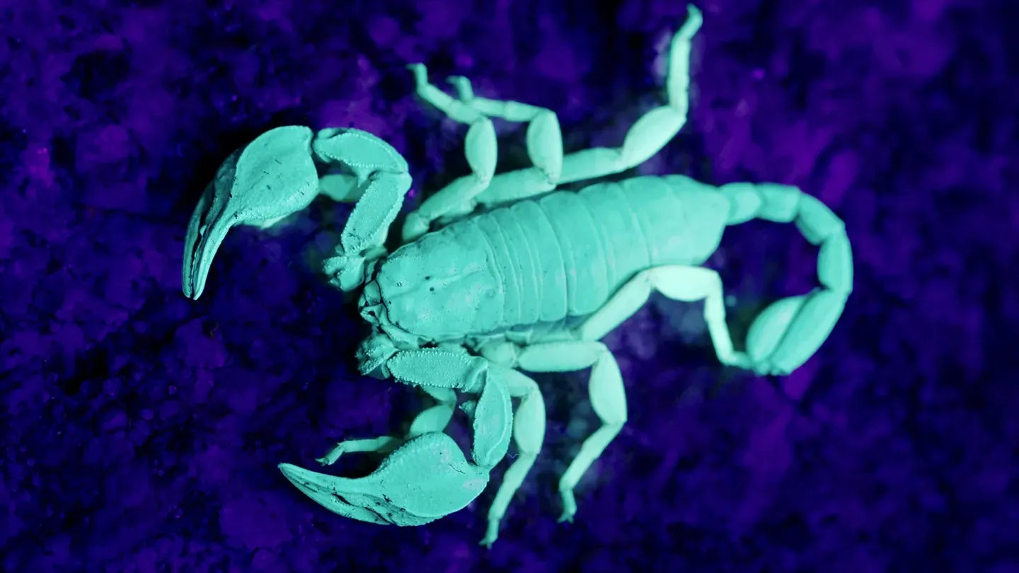
Local legend has it that, two centuries ago, scorpions arrived as stowaways on a ship from Italy carrying masonry.
They established to become the largest population of scorpions in the U.K., and these dock walls are famous for them.
But you need an ultraviolet light to find them.
The scorpions are hidden in crevices between bricks and rocks on south-facing walls of old buildings.
But under the U.V.
light, the scorpions fluoresce brightly.
It's a complete surprise to most people that there are scorpions in the U.K.
Still to this day, people don't really know why they fluoresce like this under ultraviolet light, but they certainly stand out, and it makes them much easier to find.
These are yellow-tailed scorpions, and they're so intricate.
This one, at nearly five centimeters, is almost full sized.
But you can see his powerful claws.
Although he's got a stinger, they often use their powerful claws to subdue their prey and only use their sting for defense.
Their extremely slow metabolism has enabled them to survive in the U.K.'s colder climate, as they only need to feed four or five times a year.
♪♪ Believe it or not, there's around 10,000 of these yellow-tailed scorpions just at these docks alone.
And it's not known if they're spreading to other parts of the island.
♪♪ On the very final part of our journey, we're heading to the Red Sand sea forts.
Here, seven naval forts were built to make sure no other unwanted guests arrived during World War II.
Following the invasion of the Channel Islands, the sea forts were built mainly to prevent the British mainland falling under Nazi control.
♪♪ The forts were equipped with high caliber gun batteries to deter German ships and anti-aircraft guns to prevent attempts to lay mines in London's vital sea lanes.
♪♪ The strategy worked, and at least one German E-boat was engaged and destroyed.
♪♪ Most of the sea forts are now derelict, but exploring them reveals layers of World War II history.
These forts were built in 1942 and '43, and at their peak, over 200 men were stationed across these seven forts.
Each one would have either an anti-aircraft gun or a spotlight to intercept those enemy planes on their way to attack London.
This is one of the old ammo stores where shells would be kept ready to be fired by the anti-aircraft guns.
The towers also watched out for enemy E-boats.
These were fast-moving vessels that would come into the Thames Estuary and lay mines that destruct these vitally important shipping lanes that supplied London and much of Britain.
If enemy vessels came close enough, they could also engage and shoot at the ships.
The sea forts were involved in spotting enemy aircraft and V-1 flying bombs, saving hundreds of lives.
[ Plane engines, gunfire ] ♪♪ By the late 1950s, the forts were decommissioned, and now they're slowly deteriorating.
♪♪ The islands that surround Britain have helped shape the country's history.
They've nurtured countless communities and cultures over the centuries and are home to unique species of animals and plants that are found nowhere else on Earth.
From tiny rocks in the middle of nowhere, to dramatic stacks, and even artificial islands that past generations built for their homes and to defend their lands, the 6,000 islands that make up the British Isles are the very fabric of this country.
♪♪ ♪♪ ♪♪ ♪♪ ♪♪


